A planned trip from our hometown Townsville to Cairns always worries me a bit especially in the wet season. The leg is 150 nm, about 1. 5 hours with our Grumman. We have not had a real wet season this year and the weather was pretty good but come Christmas day and it looks like the wet season has begun. Fortunately on Boxing Day the weather improved considerably but Cairns or enroute may be different kettle of fish. And than of course what is the weather going to be like on planned departure in Cairns two days later. Maybe I worry too much but I have been stuck there several times and departed in marginal weather. In hindsight as it turns out there was not much too be worried about. Everything went smooth apart on checking the airplane prior departure Cairns finding the right tire totally flat. Horror what are we going to do now? Fortunately I found someone and for a carton of beer he supplied us with oxygen and I learnt how to fill up all the tires on the Grumman. A bit trick but ok.
Paul, my son a commercial pilot flew to Cairns and I flew back home again.
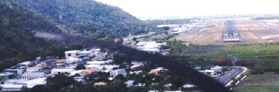
Departing Townsville climbing to 6500 feet flying direct over these reef protected waters, abeam Palm Island (32miles), Orpheus Island, Hinchenbrook Island a national park, now 70 miles from Townsville, over to Dunk Island, about half way now and watching out and listening out on the radio for any parachute jumping activities, than another 20 miles towards township of Innisfail with another 40 nm to go through the valley to our final destination Cairns, to name just a few. From Dunk Island we could have remain coastal avoiding Innisfail CTAF, more parachute operation and the valley and track for the cape. The valley can have a fair amount of lower clouds due to the orographic uplift caused by the usual easterly winds from the ocean. We decided to take the straight shorter and direct leg as flight planned through the valley. The clouds starting to built up but it looks fine to continue and to decent to 2500 feet and approach the airport from underneath cloud and call for clearance a bit later. The TAF forecast for YBCS was ok and we could have remained at 6500 feet but with the amount of cloud built up prior Cairns and with Cairn being a busy international airport we decided to call later and lower for clearance. As it turned out we got clearance very quickly without any fuss just past Babinda. If there is too much low clouds over the valley, once past Innisfail there is another option to divert coastal and track Cairns via Cape. If at 500 feet, airways clearance needs to be obtained from the tower and not approach (see ERSA). This is a slightly longer route, adds another 10 nm to your leg.
On departure back home to Townsville from Cairns we got clearance runway 15 and our track back happens to be 151 degrees back home again. Here again there are some cloud built up over the valley but we managed to clear them on climb to 7500 feet. Had to ask clearance to divert 3 miles left of our track to manage to clear clouds but once established at 7500 feet and past Innisfail the sky was mainly blue. I have often found, even so Cairns is much busier than Townsville and both being class C airspace, Cairns has less delays when obtaining clearance and on final approach or take off. I think they are more accustomed to being busy.
Photo:
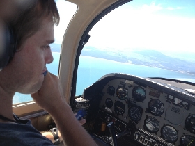
Paul piloting our Grumman Tiger enroute Townsville to Cairns positioned abeam Palm Island about 30 nm Townsville with coastline on the Left hand side.
Eric
Ps: More photos on http:www. aviatecenter. comindex. php?action=stories
 Enlarge image